Mountain biking tours
Tour tips from mountain bikers for mountain bikers in the Salzkammergut

Your hosts Andrea and Bernhard are well acquainted with the region - Bernhard himself moreover is a certified mountainbike-guide. They both are at your disposal in the mornings and evenings for tour tips for mountain bikers in the Salzkammergut.
Landhotel Agathawirt has a wide range of offers for mountain bikers:
- We offer: 3 guided tours per week in at least 2 ability groups. At least 1 additional easy tour per week for beginners. Euro 85,- per tour and person.
- For e-mountain bikers there are special guided e-mountain bike tours incl. technique training. From 2 persons - Euro 170,- per tour.
Our special mountain biking tour tips
- the Hallstättersee-Koppenwinkel-Round – 30 km, 150 metres of change in altitude – wonderful sight to the village of Hallstatt – nature of Koppenwinkelsee
- the Weissenbach Round – 21 km, 240 metres of change in altitude – our tour for the afternoon after your trip
- the Hochmuth-Round – 23 km, 500 meters of change in altitude – nice tour for half- a – day
- the Blaa-Alm Round– 45.5 km, 960 metres of change in altitude – a classic to get started and get to know the region, but also THE tour to take when it is very hot, since most of the change in altitude has to be conquered at the beginning of the tour and Altaussee Lake is a welcome stop off to cool down

- the Kaiser Tour – 38 km, 770 metres of change in altitude – The tour doesn't just earn its name Kaiser Tour because it leads through the forests and along the paths that Franz and Sis once travelled on foot and by carriage, but primarily because of the highlights it offers. You will see the Ewige Wand and the Tauernweg to Ischl and it has lots of cozy cabins with the Ratluck'n and Hoisenradalm to offer.
- the Sandling-Round - 35 km, 1350 metres of change in altidude – have a break at lake Altausee and a Kaiserschmarrn at the Hütteneck-hut
- the Raschberg Round – 52.50 km, 1,610 metres of change in altitude – Into the Ausseerland and over the challenging Grabenbach back up to the Raschberg – marvelous view of one of the best-known mountain meadows in the Salzkammergut – the Hütteneckalm – the Kaiserschmarrn alone is reason enough for a visit!
- the Durchgangsalm-Round – 48 km, 1380 Hütteneckalm – The tour starts on Lake Hallstatt and leads along the new bike path with a view of the world-famous city of Hallstatt before the path becomes steep in the Echerntal on the way to Gosau – a tour that offers everything – beautiful views, cosy meadows, challenging inclines and declines.
- the Salzkammergut 5 Lake Tour (lake Wolfgangsee, Schwarzensee, etc.) – 60 km, 1350 Hütteneckalm – Mountains and lakes: a combination that the Salzkammergut presents spectacularly, beautiful views and also very appropriate for bikers who without a lot of technical skills.
The team of Landhotel Agathawirt will be happy to help you with your mountain bike plans. Send us your no-obligation enquiry for your mountain bike holidays today.
Mountain bike tours in the Salzkammergut
Find the perfect tour for you. Filter the mountain bike tours according to criteria such as altitude, kilometres, duration, difficulty or riding technique. Then download the tour data as a PDF file or GPS data and look forward to your MTB day in the Salzkammergut.
Circular hike from Innerschwand to the lookout tower Kulmspitz


5310 Innerschwand am Mondsee

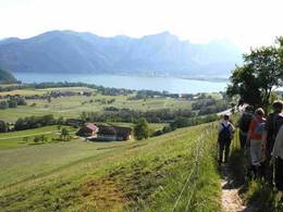
Beautiful but challenging circular hike through the municipality of Innerschwand to the Kulmspitz with its new lookout-tower.
After the start the path leads to the village centre of Loibichl, past the homecomer church. Always on traffic-poor freight roads, under the west highway A1 through we reach in the district Anzenberg a forest way. From there it always goes uphill to the highest point of the hike, the Kulmspitz.
Strengthened with a summit snack we follow the hiking trail downhill. Don't forget to make a 30m long detour to the left about 200m below the summit - here a sensational panorama opens up to you at the edge of the forest.
The descent takes place on forest paths and partly on asphalted goods paths, until we reach already known terrain near Anzenberg. We follow the already known path back to the starting point at the bathing facility.
Tip: Don't forget your swimsuit so that you can end the day with a jump into the Mondsee.
Paths covering:
further information:
- Flatly


Start and end of the tour is at the beach in Innerschwand, approx. 6 km in the direction to Unterach am Attersee.
In the summer months (1st of May and 30th of September) EUR 3.00 per car.
- Suitable for teenagers
- Suitable for single travelers
- Suitable for friends
- Suitable for couples
- Spring
- Summer
- Autumn
Please get in touch for more information.
")
Dr. Franz Müller Str. 3
5310 Innerschwand am Mondsee
Phone +43 6232 2265
E-Mailinfo@mondsee.at
Webmondsee.salzkammergut.at/
")
")
")
")


