Mountain biking tours
Tour tips from mountain bikers for mountain bikers in the Salzkammergut

Your hosts Andrea and Bernhard are well acquainted with the region - Bernhard himself moreover is a certified mountainbike-guide. They both are at your disposal in the mornings and evenings for tour tips for mountain bikers in the Salzkammergut.
Landhotel Agathawirt has a wide range of offers for mountain bikers:
- We offer: 3 guided tours per week in at least 2 ability groups. At least 1 additional easy tour per week for beginners. Euro 85,- per tour and person.
- For e-mountain bikers there are special guided e-mountain bike tours incl. technique training. From 2 persons - Euro 170,- per tour.
Our special mountain biking tour tips
- the Hallstättersee-Koppenwinkel-Round – 30 km, 150 metres of change in altitude – wonderful sight to the village of Hallstatt – nature of Koppenwinkelsee
- the Weissenbach Round – 21 km, 240 metres of change in altitude – our tour for the afternoon after your trip
- the Hochmuth-Round – 23 km, 500 meters of change in altitude – nice tour for half- a – day
- the Blaa-Alm Round– 45.5 km, 960 metres of change in altitude – a classic to get started and get to know the region, but also THE tour to take when it is very hot, since most of the change in altitude has to be conquered at the beginning of the tour and Altaussee Lake is a welcome stop off to cool down

- the Kaiser Tour – 38 km, 770 metres of change in altitude – The tour doesn't just earn its name Kaiser Tour because it leads through the forests and along the paths that Franz and Sis once travelled on foot and by carriage, but primarily because of the highlights it offers. You will see the Ewige Wand and the Tauernweg to Ischl and it has lots of cozy cabins with the Ratluck'n and Hoisenradalm to offer.
- the Sandling-Round - 35 km, 1350 metres of change in altidude – have a break at lake Altausee and a Kaiserschmarrn at the Hütteneck-hut
- the Raschberg Round – 52.50 km, 1,610 metres of change in altitude – Into the Ausseerland and over the challenging Grabenbach back up to the Raschberg – marvelous view of one of the best-known mountain meadows in the Salzkammergut – the Hütteneckalm – the Kaiserschmarrn alone is reason enough for a visit!
- the Durchgangsalm-Round – 48 km, 1380 Hütteneckalm – The tour starts on Lake Hallstatt and leads along the new bike path with a view of the world-famous city of Hallstatt before the path becomes steep in the Echerntal on the way to Gosau – a tour that offers everything – beautiful views, cosy meadows, challenging inclines and declines.
- the Salzkammergut 5 Lake Tour (lake Wolfgangsee, Schwarzensee, etc.) – 60 km, 1350 Hütteneckalm – Mountains and lakes: a combination that the Salzkammergut presents spectacularly, beautiful views and also very appropriate for bikers who without a lot of technical skills.
The team of Landhotel Agathawirt will be happy to help you with your mountain bike plans. Send us your no-obligation enquiry for your mountain bike holidays today.
Mountain bike tours in the Salzkammergut
Find the perfect tour for you. Filter the mountain bike tours according to criteria such as altitude, kilometres, duration, difficulty or riding technique. Then download the tour data as a PDF file or GPS data and look forward to your MTB day in the Salzkammergut.
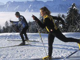
Bad Goisern, St. Agatha - Reitern - Stambach cross-country ski trail


Interactive elevation profile
Create PDF
Tour-Details
Paths covering:
The St. Agatha - Reitern - Stambach cross-country ski trail in Bad Goisern on Lake Hallstatt - also known as the "Trüfö Loipe" - makes the heart of a pleasure cross-country skier beat faster.
Sunny, easy cross-country ski trail
This sunny, easy-to-master trail runs through three villages from Bad Goisern am Hallstättersee.
It is largely flat, without significant ascents and descents.
Enjoy the surrounding mountain world of the Inner Salzkammergut, be it on the diagonal or skating track.
TIP: The cross-country ski trail also leads to the small Catholic Filialkirche in St. Agatha.
Download the cross-country ski trail map of Bad Goisern here.
Experience a 360° panoramic tour through Bad Goisern on Lake Hallstatt...
Details - Trail
- Nordic skiing facilities: Marked Nordic skiing run
- Type of Nordic skiing run: Classic + skating
- free
December to March, depending on snow conditions.
Parking and access: in the village of Edt (entrance opposite the Aigner car dealership), a car park is cleared for cross-country skiers in the winter months.
By car
From Salzburg:
Exit Thalgau via the B158 federal road towards Bad Ischl, in Bad Ischl take the B145 Salzkammergut road towards Bad Goisern.
From Linz:
Regau motorway exit onto Salzkammergut Straße B145 towards Gmunden and Bad Ischl to Bad Goisern.
From Vienna/Graz:
Liezen motorway exit onto B320, in Trautenfels turn off onto Salzkammergut Straße B145 to Bad Goisern.
From Villach:
Tauern motorway to exit "Eben im Pongau", via B166 Pass Gschütt Bundesstraße through Gosau, turn left at the Gosaumühle junction towards Bad Goisern.
By train
Train Attnang-Puchheim - Stainach-Irdning:
Stops Goisern Jodschwefelbad, Bad Goisern railway station, Steeg / Gosau.
By bus
Bus 541 & 542 (Bad Ischl - Lake Gosau):
Stops Bad Goisern Jodschwefelbad, Bad Goisern Kurhotel, Bad Goisern Mitte/B145, Stambach StrKrzg., St. Agatha Agathawirt, Stambach Angerer, Steeg Reitern, Steeg Au, Steeg Bahnhof, Steeg Traunbrücke, Steeg E-Werk.
Detailed information on the respective train and bus times can be found here!
- Parking space: 5
All cross-country ski trails in the Goiserertal can be used free of charge.
- Free entry
- Suitable for schools
- Suitable for kids (6 - 14 Year)
- Suitable for teenagers
- Suitable for seniors
- Suitable for single travelers
- Suitable for friends
- Suitable for couples
- Deep winter
Please get in touch for more information.
")
Bad Goisern, St. Agatha - Reitern - Stambach cross-country ski trail Auskunft: Tourismusverband Inneres Salzkammergut
Kirchengasse 4
4822 Bad Goisern am Hallstättersee
Phone +43 5 95095 - 10
E-Mailgoisern@dachstein-salzkammergut.at
Webdachstein.salzkammergut.at
You can also visit us on
Visit us on Facebook Visit us on Instagram Visit us on TikTok Visit us on Pinterest Visit our videochannel on YouTube Wikipedia")
Interactive elevation profile
Create PDF
Tour-Details
Paths covering:


