Mountain biking tours
Tour tips from mountain bikers for mountain bikers in the Salzkammergut

Your hosts Andrea and Bernhard are well acquainted with the region - Bernhard himself moreover is a certified mountainbike-guide. They both are at your disposal in the mornings and evenings for tour tips for mountain bikers in the Salzkammergut.
Landhotel Agathawirt has a wide range of offers for mountain bikers:
- We offer: 3 guided tours per week in at least 2 ability groups. At least 1 additional easy tour per week for beginners. Euro 85,- per tour and person.
- For e-mountain bikers there are special guided e-mountain bike tours incl. technique training. From 2 persons - Euro 170,- per tour.
Our special mountain biking tour tips
- the Hallstättersee-Koppenwinkel-Round – 30 km, 150 metres of change in altitude – wonderful sight to the village of Hallstatt – nature of Koppenwinkelsee
- the Weissenbach Round – 21 km, 240 metres of change in altitude – our tour for the afternoon after your trip
- the Hochmuth-Round – 23 km, 500 meters of change in altitude – nice tour for half- a – day
- the Blaa-Alm Round– 45.5 km, 960 metres of change in altitude – a classic to get started and get to know the region, but also THE tour to take when it is very hot, since most of the change in altitude has to be conquered at the beginning of the tour and Altaussee Lake is a welcome stop off to cool down

- the Kaiser Tour – 38 km, 770 metres of change in altitude – The tour doesn't just earn its name Kaiser Tour because it leads through the forests and along the paths that Franz and Sis once travelled on foot and by carriage, but primarily because of the highlights it offers. You will see the Ewige Wand and the Tauernweg to Ischl and it has lots of cozy cabins with the Ratluck'n and Hoisenradalm to offer.
- the Sandling-Round - 35 km, 1350 metres of change in altidude – have a break at lake Altausee and a Kaiserschmarrn at the Hütteneck-hut
- the Raschberg Round – 52.50 km, 1,610 metres of change in altitude – Into the Ausseerland and over the challenging Grabenbach back up to the Raschberg – marvelous view of one of the best-known mountain meadows in the Salzkammergut – the Hütteneckalm – the Kaiserschmarrn alone is reason enough for a visit!
- the Durchgangsalm-Round – 48 km, 1380 Hütteneckalm – The tour starts on Lake Hallstatt and leads along the new bike path with a view of the world-famous city of Hallstatt before the path becomes steep in the Echerntal on the way to Gosau – a tour that offers everything – beautiful views, cosy meadows, challenging inclines and declines.
- the Salzkammergut 5 Lake Tour (lake Wolfgangsee, Schwarzensee, etc.) – 60 km, 1350 Hütteneckalm – Mountains and lakes: a combination that the Salzkammergut presents spectacularly, beautiful views and also very appropriate for bikers who without a lot of technical skills.
The team of Landhotel Agathawirt will be happy to help you with your mountain bike plans. Send us your no-obligation enquiry for your mountain bike holidays today.
Mountain bike tours in the Salzkammergut
Find the perfect tour for you. Filter the mountain bike tours according to criteria such as altitude, kilometres, duration, difficulty or riding technique. Then download the tour data as a PDF file or GPS data and look forward to your MTB day in the Salzkammergut.
Traunreiterweg


- Suitable for families
- Suitable for pushchairs
Interactive elevation profile
Create PDF
Tour-Details
Paths covering:
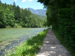
One of the most popular hiking and walking trails in Bad Goisern along the Traun. Especially for families with children (also accessible with a pushchair) an ideal hiking trail.
Family-friendly, easy walk
Along the Traun in the Weißenbach area is the newly developed Traunreiterweg trail, which provides the ideal conditions for a beautiful excursion!
In front of the Goisererbrücke bridge (near the centre Bad Goisern am Hallstättersee), you walk right past Bad Goisern railway station towards Weißenbachbrücke, always accompanied by the rushing of the tireless Traun river. With a walking time of approx. 1 hour 15 minutes, this trail has been one of the most popular running and walking trails for many years. The level and easy path is also perfectly suitable for families with pushchairs or wheelchair users!
Where does the name Traunreiter come from?
The Traunreiter existed from the 16th to the 19th century. They were salt boatmen who transported the salt extracted in Hallstatt on the Traun to the salt works in Ebensee. On the way back, the ships were loaded with grain, wine and other provisions and were pulled back on land by horses towards Hallstatt, hence the name.
Only non-swimmers were employed as Traun riders for the sole reason that they did not leave the ship in case of danger. Furthermore, no women were taken on board as it was firmly believed that women chatted away during the journey and therefore no longer paid attention to the dangers during the journey.
Fancy more hikes?
You can find interesting facts about the culture and history of Bad Goisern on the themed trail "Goiserer Geschichte(n)" . You can find more recommendations in our Overview of all hiking trails in the Dachstein Salzkammergut holiday region.
In case of emergency: Mountain Rescue 140
Experience a 360° panoramic tour through Bad Goisern on Lake Hallstatt...
Details - hiking
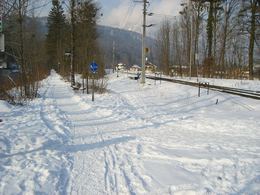
- cleared winter hiking path
Accessible all year round
")
")

By car
From Salzburg:
Exit Thalgau via the B158 federal road towards Bad Ischl, in Bad Ischl take the B145 Salzkammergut road towards Bad Goisern.
From Linz:
Regau motorway exit onto Salzkammergut Straße B145 towards Gmunden and Bad Ischl to Bad Goisern.
From Vienna/Graz:
Liezen motorway exit onto B320, in Trautenfels turn off onto Salzkammergut Straße B145 to Bad Goisern.
From Villach:
Tauern motorway to exit "Eben im Pongau", via B166 Pass Gschütt Bundesstraße through Gosau, turn left at the Gosaumühle junction towards Bad Goisern.
By train
Train Attnang-Puchheim - Stainach-Irdning:
Stops Goisern Jodschwefelbad, Bad Goisern railway station, Steeg / Gosau.
By bus
Bus 541 & 542 (Bad Ischl - Lake Gosau):
Stops Bad Goisern Jodschwefelbad, Bad Goisern Kurhotel, Bad Goisern Mitte/B145, Stambach StrKrzg., St. Agatha Agathawirt, Stambach Angerer, Steeg Reitern, Steeg Au, Steeg Bahnhof, Steeg Traunbrücke, Steeg E-Werk.
Detailed information on the respective Train- and Bus times can be found here!
- Free entry
- Suitable for groups
- Suitable for schools
- Suitable for pushchairs
- Suitable for teenagers
- Suitable for seniors
- Suitable for single travelers
- Suitable for families
- Suitable for friends
- Suitable for couples
- Suitable for children
- Spring
- Summer
- Autumn
- Early winter
- Deep winter
Suitable for wheelchairs: Not all of the legally stipulated ÖNORM are complied with. In principle, this object is suitable for wheelchairs and no assistance is necessary.
Traunreiterweg Marktgemeinde Bad Goisern
Untere Marktstraße 1
4822 Bad Goisern am Hallstättersee
Phone +43 6135 8301 - 0
E-Mailgemeinde@bad-goisern.ooe.gv.at
Webwww.bad-goisern.ooe.gv.at
Webdachstein.salzkammergut.at
https://dachstein.salzkammergut.at
You can also visit us on
Visit us on Facebook Visit us on Instagram Visit us on TikTok Visit us on Pinterest Visit our videochannel on YouTube Wikipedia")
Interactive elevation profile
Create PDF
Tour-Details
Paths covering:


