Mountain biking tours
Tour tips from mountain bikers for mountain bikers in the Salzkammergut

Your hosts Andrea and Bernhard are well acquainted with the region - Bernhard himself moreover is a certified mountainbike-guide. They both are at your disposal in the mornings and evenings for tour tips for mountain bikers in the Salzkammergut.
Landhotel Agathawirt has a wide range of offers for mountain bikers:
- We offer: 3 guided tours per week in at least 2 ability groups. At least 1 additional easy tour per week for beginners. Euro 85,- per tour and person.
- For e-mountain bikers there are special guided e-mountain bike tours incl. technique training. From 2 persons - Euro 170,- per tour.
Our special mountain biking tour tips
- the Hallstättersee-Koppenwinkel-Round – 30 km, 150 metres of change in altitude – wonderful sight to the village of Hallstatt – nature of Koppenwinkelsee
- the Weissenbach Round – 21 km, 240 metres of change in altitude – our tour for the afternoon after your trip
- the Hochmuth-Round – 23 km, 500 meters of change in altitude – nice tour for half- a – day
- the Blaa-Alm Round– 45.5 km, 960 metres of change in altitude – a classic to get started and get to know the region, but also THE tour to take when it is very hot, since most of the change in altitude has to be conquered at the beginning of the tour and Altaussee Lake is a welcome stop off to cool down

- the Kaiser Tour – 38 km, 770 metres of change in altitude – The tour doesn't just earn its name Kaiser Tour because it leads through the forests and along the paths that Franz and Sis once travelled on foot and by carriage, but primarily because of the highlights it offers. You will see the Ewige Wand and the Tauernweg to Ischl and it has lots of cozy cabins with the Ratluck'n and Hoisenradalm to offer.
- the Sandling-Round - 35 km, 1350 metres of change in altidude – have a break at lake Altausee and a Kaiserschmarrn at the Hütteneck-hut
- the Raschberg Round – 52.50 km, 1,610 metres of change in altitude – Into the Ausseerland and over the challenging Grabenbach back up to the Raschberg – marvelous view of one of the best-known mountain meadows in the Salzkammergut – the Hütteneckalm – the Kaiserschmarrn alone is reason enough for a visit!
- the Durchgangsalm-Round – 48 km, 1380 Hütteneckalm – The tour starts on Lake Hallstatt and leads along the new bike path with a view of the world-famous city of Hallstatt before the path becomes steep in the Echerntal on the way to Gosau – a tour that offers everything – beautiful views, cosy meadows, challenging inclines and declines.
- the Salzkammergut 5 Lake Tour (lake Wolfgangsee, Schwarzensee, etc.) – 60 km, 1350 Hütteneckalm – Mountains and lakes: a combination that the Salzkammergut presents spectacularly, beautiful views and also very appropriate for bikers who without a lot of technical skills.
The team of Landhotel Agathawirt will be happy to help you with your mountain bike plans. Send us your no-obligation enquiry for your mountain bike holidays today.
Mountain bike tours in the Salzkammergut
Find the perfect tour for you. Filter the mountain bike tours according to criteria such as altitude, kilometres, duration, difficulty or riding technique. Then download the tour data as a PDF file or GPS data and look forward to your MTB day in the Salzkammergut.
Kreuzstein - Eisenau Alp - Schafberg


5310 Mondsee am Mondsee

Description: An early onset of winter in September 2024 caused countless trees to fall across the hiking trail between Eisenau and Suissensee. The path is passable with severe restrictions. It is currently not possible for volunteers to repair the forest damage in this inaccessible area due to the danger to life. A solution to the problem is being worked on.
One of many ways to conquer the Schafberg!
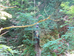
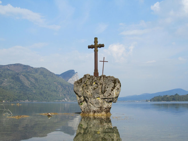
Caution - alpine experience required from Eisenau-Alm!We park at the car park of the public state bathing area. In the water we see a stone with two crosses after which the area here is named "Kreuzstein" . From there, the trail climbs steeply into the forest, where the Waterfall Kreuzstein awaits us as the first highlight after 10 minutes. Continuing up through the forest over several streams and a spectacular bridge construction with well-secured ladders, we reach a hunting lodge with a fantastic view over Lake Mondsee. From here, it is only a few minutes until we reach the Eisenauer Alm. This route is also suitable for children and is a unique experience.
At Eisenau, turn right across alpine meadows and back into the forest. This is followed by a steep ascent to Suissensee. Once at the top, turn right and continue under the Schafberg summit. The last section is the so-called Himmelspforte - it gets a little tricky here. The steep and rocky path is very demanding for hikers and should only be tackled in dry conditions.
The Schafberg awaits us with a fantastic view!
Paths covering:
further information:
- Board possible
Direction information: Departure


Direction information: Destination
")
")
")
")
")
")
")


From Salzburg via the A1 - Mondsee exit
From Vienna/Linz via the A1 - St. Georgen exit, Attersee via Nußdorf to Unterach
From the west - Bad Ischl-Weißenbach-Unterach
Train:
From Salzburg or Linz/Vienna to Vöcklamarkt. Linz/Vienna to Vöcklamarkt, continue with the Attergau Bahn to Attersee, continue by bus to Unterach
Airplane:
From Salzburg via the A1 - Mondsee exit
From Vienna/Linz via the A1 - St. Georgen exit
- Spring
- Summer
Please get in touch for more information.
Dr. Franz Müller Straße 3
5310 Mondsee am Mondsee
Phone +43 6232 2270
Fax machine +43 6232 2270
E-Mailinfo@mondsee.at
Webmondsee.salzkammergut.at
Webattersee-attergau.salzkammergut.at
https://attersee-attergau.salzkammergut.at
You can also visit us on
Facebook Instagram Pinterest YouTube Wikipedia

