Road biking tours in the Salzkammergut
Various racing bicycle tours in the Salzkammergut region

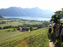
Reel off uncountable kilometres, feel the wind in your helmet and test your physical boundaries: many sportspeople just cannot resist the temptation of the narrow wheels.
Go to new places with your road bike: in the road biking region Salzkammergut you go through wonderful lake and mountain landscapes of a unique variety during your road biking tours.
Bad Goisern – road biking tour to the Attersee variant 1
This beautiful tour takes you to the most beautiful Salzkammergut lakes.
Starting from Landhotel Agathawirt in Bad Goisern you take the main road B145 to the emperor’s town Bad Ischl. At the junction Bad Ischl Nord you take the road to Ebensee / Gmunden. Before reaching Ebensee you turn left into the Weißenbachtal valley (B153) and reach Weißenbach am Attersee. Via Strobl and Bad Ischl you finally go back to Bad Goisern.
Bad Goisern – Attersee with the racing bike variant II - long
The first part of this variant is the same as variant I until Weißenbach am Attersee. Then you cycle anti-clockwise around the Attersee and pass the villages Steinbach, Weyregg, Schörfling and Seewalchen, Attersee, Nussdorf and finally Unterach. Here you take the road to Mondsee. Just as in variant I you then go via Wiesenau and Schafling to St. Gilgen, then on to Strobl and Bad Ischl until you reach Landhotel Agathawirt in Bad Goisern.
Bad Goisern – Strobl on the racing bike
A beautiful and easy racing bike tour from Bad Goisern to Lake Wolfgang and through the emperor’s town Bad Ischl. Along the main road B145 you go slightly downhill to Bad Ischl. On a parallel path to the main road you cross the emperor’s town before you bike on a short stretch of the main road B158 to Pfandl. There you turn right at the traffic lights to the “Alte Wolfgangseestraße” L546. Via Wirling and Radau the road goes to Strobl and from here along the B158 back to the starting point in Bad Goisern.

Obertraun – Bad Aussee road biking tour
This tour leads you through the picturesque Koppental valley.
From the hotel you take the east shore hiking and biking path to Obertraun. There you make a turn to the road leading into the Koppental valley before you conquer the steepest part, the Koppenpass with a challenging gradient of max. 23%. On you go to Bad Aussee and then on the main road B145 towards Bad Goisern. At the traffic junction Bad Goisern Süd you turn to the main road B153 towards Gosaumühle. Here you turn at the junction and go via Hallstatt and Obertraun back to Hotel Agathawirt.
Road bike holidays in Landhotel Agathawirt
Have we wetted your appetite to explore the unique natural landscape of the Dachstein-Salzkammergut with the road bike? Bikers will be very well cared for in Landhotel Agathawirt and will always receive valuable tips for their bike tours by the hosts themselves. Send us a no-obligation enquiry for your holidays in Landhotel Agathawirt in Bad Goisern!
Selected road bike routes around Bad Goisern
Circular hike from Innerschwand to the lookout tower Kulmspitz


5310 Innerschwand am Mondsee

Beautiful but challenging circular hike through the municipality of Innerschwand to the Kulmspitz with its new lookout-tower.
After the start the path leads to the village centre of Loibichl, past the homecomer church. Always on traffic-poor freight roads, under the west highway A1 through we reach in the district Anzenberg a forest way. From there it always goes uphill to the highest point of the hike, the Kulmspitz.
Strengthened with a summit snack we follow the hiking trail downhill. Don't forget to make a 30m long detour to the left about 200m below the summit - here a sensational panorama opens up to you at the edge of the forest.
The descent takes place on forest paths and partly on asphalted goods paths, until we reach already known terrain near Anzenberg. We follow the already known path back to the starting point at the bathing facility.
Tip: Don't forget your swimsuit so that you can end the day with a jump into the Mondsee.
Paths covering:
further information:
- Flatly


Start and end of the tour is at the beach in Innerschwand, approx. 6 km in the direction to Unterach am Attersee.
In the summer months (1st of May and 30th of September) EUR 3.00 per car.
- Suitable for teenagers
- Suitable for single travelers
- Suitable for friends
- Suitable for couples
- Spring
- Summer
- Autumn
Please get in touch for more information.
")
Dr. Franz Müller Str. 3
5310 Innerschwand am Mondsee
Phone +43 6232 2265
E-Mailinfo@mondsee.at
Webmondsee.salzkammergut.at/
")
")
")
")
