Road biking tours in the Salzkammergut
Various racing bicycle tours in the Salzkammergut region

Reel off uncountable kilometres, feel the wind in your helmet and test your physical boundaries: many sportspeople just cannot resist the temptation of the narrow wheels.
Go to new places with your road bike: in the road biking region Salzkammergut you go through wonderful lake and mountain landscapes of a unique variety during your road biking tours.
Bad Goisern – road biking tour to the Attersee variant 1
This beautiful tour takes you to the most beautiful Salzkammergut lakes.
Starting from Landhotel Agathawirt in Bad Goisern you take the main road B145 to the emperor’s town Bad Ischl. At the junction Bad Ischl Nord you take the road to Ebensee / Gmunden. Before reaching Ebensee you turn left into the Weißenbachtal valley (B153) and reach Weißenbach am Attersee. Via Strobl and Bad Ischl you finally go back to Bad Goisern.
Bad Goisern – Attersee with the racing bike variant II - long
The first part of this variant is the same as variant I until Weißenbach am Attersee. Then you cycle anti-clockwise around the Attersee and pass the villages Steinbach, Weyregg, Schörfling and Seewalchen, Attersee, Nussdorf and finally Unterach. Here you take the road to Mondsee. Just as in variant I you then go via Wiesenau and Schafling to St. Gilgen, then on to Strobl and Bad Ischl until you reach Landhotel Agathawirt in Bad Goisern.
Bad Goisern – Strobl on the racing bike
A beautiful and easy racing bike tour from Bad Goisern to Lake Wolfgang and through the emperor’s town Bad Ischl. Along the main road B145 you go slightly downhill to Bad Ischl. On a parallel path to the main road you cross the emperor’s town before you bike on a short stretch of the main road B158 to Pfandl. There you turn right at the traffic lights to the “Alte Wolfgangseestraße” L546. Via Wirling and Radau the road goes to Strobl and from here along the B158 back to the starting point in Bad Goisern.

Obertraun – Bad Aussee road biking tour
This tour leads you through the picturesque Koppental valley.
From the hotel you take the east shore hiking and biking path to Obertraun. There you make a turn to the road leading into the Koppental valley before you conquer the steepest part, the Koppenpass with a challenging gradient of max. 23%. On you go to Bad Aussee and then on the main road B145 towards Bad Goisern. At the traffic junction Bad Goisern Süd you turn to the main road B153 towards Gosaumühle. Here you turn at the junction and go via Hallstatt and Obertraun back to Hotel Agathawirt.
Road bike holidays in Landhotel Agathawirt
Have we wetted your appetite to explore the unique natural landscape of the Dachstein-Salzkammergut with the road bike? Bikers will be very well cared for in Landhotel Agathawirt and will always receive valuable tips for their bike tours by the hosts themselves. Send us a no-obligation enquiry for your holidays in Landhotel Agathawirt in Bad Goisern!
Selected road bike routes around Bad Goisern
Schiederweiher - Polsterstüberl - Dietlgut


4573 Hinterstoder
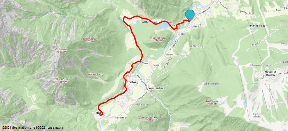
Hike to picturesque Schiederweiher lake and the Polsterstüberl, then continue to Dietlkapelle chapel and the Dietlgut.
Continue your hike as far as the Polsterstüberl, where you will branch off briefly to the left, making your way on path No. 209, along the edge of meadows, then through a forest until you reach a crossing by a bridge.
If you take the paved road to the left, you will come to the Polsterluckenwirt (2 minutes on path No. 12).
Take a right at the crossroads, and walk via path No. 209 alongside fences to the Nickergut. This path takes you through the farm, then past some houses and meadows. Shortly before you reach the Dietlgut, the Dietlkapelle is on your right. This beautiful forest chapel invites you to enjoy a reflective break. After a few more minutes, you will reach the Dietlgut.
Hiking paths Nos.: 201, 209
Paths covering:
further information:
- Board possible
Details - hiking
- cleared winter hiking path
The starting point is the parking lot Schiederweiher (paying) - about 1.5 km to the center Hinterstoder.
Parking- Parking space: 150
up to 6 hours 6.00 euros | up to 24 hours 9.00 euros 7-day parking ticket 18.00 euros | annual parking ticket 35.00 euros | The annual parking ticket entitles you to park up to two vehicle licence plates and is available at the Hinterstoder municipal office.
- Suitable for pushchairs
- Spring
- Summer
- Autumn
- Early winter
- Deep winter
Please get in touch for more information.
Hinterstoder 38
4573 Hinterstoder
Phone +43 7564 5263
E-Mailinfo@360alpenland.com
Webwww.urlaubsregion-pyhrn-priel.at/
